Most of my research into The House on Jefferson has begun with the house itself.
Who lived here? When was it built? What did it originally look like?
But eventually, I realized that if I wanted to understand the whole story of our home, I needed to go back even further.
Before the walls. Before the front porch. Before more than a century of families walked through the doors, there was simply a piece of land in a newly laid out Shreveport neighborhood called Colonial Hill.
And then I found this.
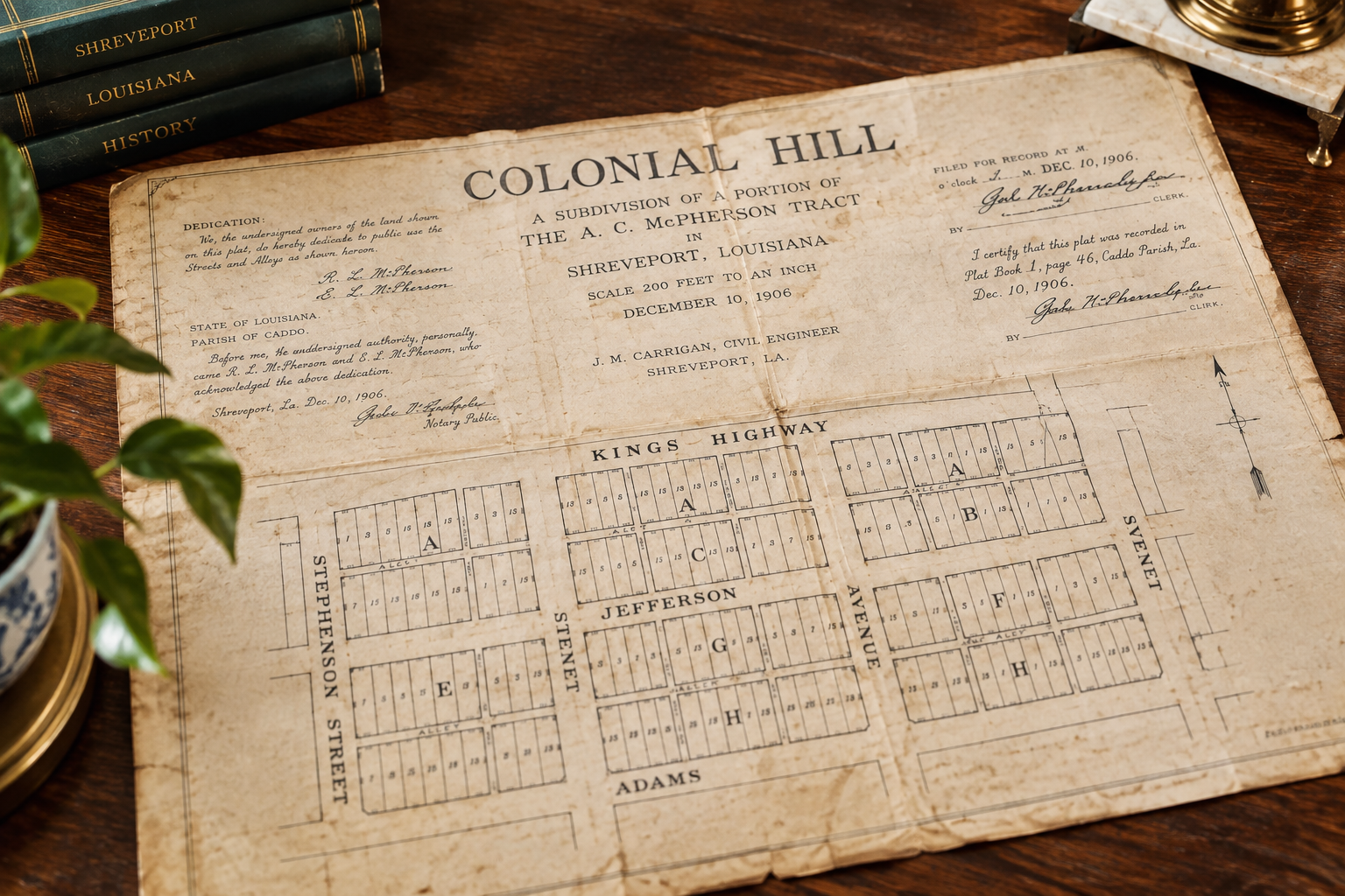
The Original Colonial Hill Plat
The original Colonial Hill subdivision plat is dated December 10, 1906.
Looking closely at the old map, I could see names that are still part of our everyday life more than a century later.
Kings Highway. Jefferson Avenue. Adams Avenue. Stephenson Street.
And there, along Jefferson, was Block F.
The block where our house would eventually stand.
There is something pretty incredible about looking at a document created so long ago and realizing that I am looking at the beginning of our little piece of Shreveport history.

The original Colonial Hill subdivision plat, dated December 10, 1906. Our property is located in Block F along Jefferson Avenue.
How I Found the Original Colonial Hill Plat
Finding this map did not happen with one simple search.
When I began researching our home, I quickly learned that old house research has a way of sending you down one trail after another. A name leads to a newspaper article. An article leads to a deed. A deed gives you a legal description. And sometimes, that little piece of information sends you more than a century into the past.
That is essentially what happened with Colonial Hill.
Our property’s legal description identifies it as Lots 6, 7, and the eastern one foot of Lot 5 in Block F of the Colonial Hill Subdivision.
Once I understood that description, I wanted to see the original map that created those lots.
In September 2025, I contacted the Caddo Parish Clerk of Court and requested the recorded subdivision plat for Colonial Hill, specifically asking about Block F. I was also trying to determine the original Plat Book and page so I could trace the record back to its source.
Colonial Hill dates to 1906, which meant I was dealing with records considerably older than the house itself.
And eventually, there it was.
A map drawn more than a century ago showing the streets, blocks, alleys and individual lots of a developing Shreveport neighborhood.
Finding Block F
The first thing I did was start looking for familiar street names.
Kings Highway.
Jefferson Avenue.
Adams Avenue.
Stephenson Street.
These were not modern labels added to an old map. They appear on the plat itself.
And sitting along Jefferson Avenue is Block F.
That was the moment this stopped feeling like simply another document in my research folder.
I was looking at the land beneath our home before our home was there.
The lines dividing the lots were already drawn. Jefferson Avenue already had its name. Colonial Hill had been laid out on paper.
Our house’s story had not begun yet, but the place where that story would unfold had.
What the 1906 Plat Does and Does Not Tell Us
This distinction is important as we continue documenting the history of our home.
The date 1906 does not mean our house was built in 1906.
A subdivision plat documents the division and arrangement of land. It establishes things such as blocks, lots, streets and alleys.
The house came later.
That actually makes this document more interesting to me because it gives us a true before picture.
Not a photograph of the house before someone remodeled it.
Not a newspaper clipping about one of its early residents.
A picture of the neighborhood before there was a House on Jefferson at all.
And now, more than a century later, Joey and I can stand on that same piece of ground and trace it back to the little lines drawn on this 1906 map.
For Anyone Researching an Old Shreveport Home
One of the reasons I want to share the research process here is because someone else may be sitting in an old Shreveport house wondering exactly the same things I was.
Who owned this land first?
When was my street laid out?
What was here before my house?
A subdivision plat can be one of those records that suddenly puts several pieces together.
For Caddo Parish research, the Caddo Parish Clerk of Court property records are an excellent place to start. Their records can help researchers work backward through conveyances, mortgages, plats and other documents connected with a piece of property.
Caddo Parish Clerk of Court Property Records
And Now We Go Forward
Finding the 1906 Colonial Hill plat answered one question, but naturally it created another.
There were our lots.
There was Block F.
There was Jefferson Avenue.
But who owned this little piece of Colonial Hill next?
That question takes us from the creation of the neighborhood into the people, property transactions and records that eventually lead us to the house standing here today.
And that is the part of the story I am still piecing together.
Join the Conversation
If you live in an older home, have you ever tried tracing the history of the land beneath it?
I would love to hear what you have found. Leave a comment below and tell me about your house, your neighborhood, or the oldest record you have managed to uncover.

Leave a Reply